State of the LC, 15 January 2021 - trip beyond the Los Padres
[land-cruiser Before the pandemic, my landcruiser was a daily driver (unless I was bicycle commuting) that I also wanted to use as a camping and backpacking asset. I imagined that it could help my family access remote camp sites and trailheads away from the car camping crowds and pandemic-era backpackers. Today, I was taught how to do that.
Through my local off-roading club, Trailcrew 4x4, I met Bob and Karen Van Der Sluis, a couple with an FJ80 and an RTT who regularly use their rig to explore the areas around the Los Padres wilderness. They look for campsites and trailheads that are accessible only to those who have rugged, high-clearance rigs, like ours. Bob agreed to meet me1 in the Los Padres today to show me a couple places they like to explore. I’ll refer to the locations as Soledad Road and Telephone Road, psuedonyms2 that will help keep the routes lightly traveled in these pandemic times.
A couple days ago, I messaged him asking if he knew of places in the Los Padres to explore in a landcruiser. He generously responded by telling me about Soledad Road and Telephone Road. I looked them up on AllTrails. Both showed up as hiking trails. Oddly, neither mentioned OHVs. Each route followed a dirt road, yet their descriptions agreed with what little Bob had messaged me about them (on Soledad, “at about the 10 mile point, there’s a campsite and going further is knarly”). I had no reason to distrust the AllTrail descriptions, but today I learned that they were not telling the whole story.
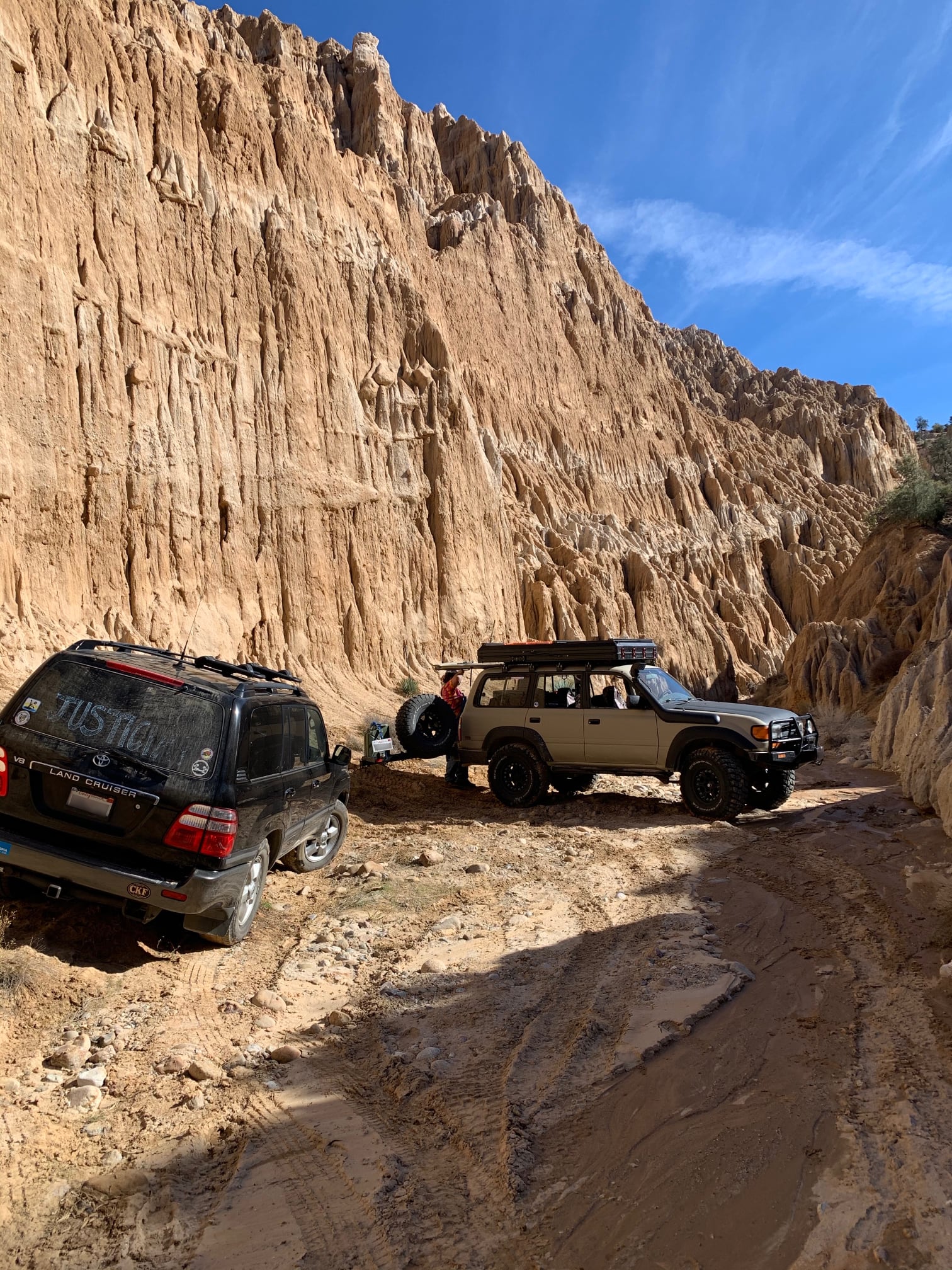
On a lark, I messaged Bob to ask if he’d want to drive Soledad and Telephone this weekend. He replied quickly with a ‘sure’. We arranged to meet where Soledad Road meets highway blacktop. I arrived first and sat on my open tailgate to read a book and wait. Before I saw their rig, I heard the rumble whine of their FJ80’s 37” BFGs on the highway pavement. When they pulled up next to me on the dirt sideroad, I saw their RTT and after our masked hellos I said, “That’s a nice rig!” Then we talked about what we wanted to do. I told them that I was learning to explore, learning about my vehicle (its approach and departure angles, how it handled on the trail, and such), and learning about someplace new. Beyond that, I wasn’t interested in mudding or rock crawling or anything technical.
My first lesson came while we were talking. Karen said, “We’ve usually gone down here,” pointing down to a dry, sandy creek bed paralleling the road we were on, “but someone piled brush in the way. So we’ll drive up the road a little and then get down.” And we did, jumping into the creek bed at the first place (of many) the road criss-crossed it. Our route exited the creek a couple times to stay off posted private property, but otherwise it stayed in the sandy wash. The creek was clearly well traveled between the highway and the place we had to turn around, 10 miles in. Along the way, there were several spur trails and many campsites dotting the banks of the dry creek. As I was driving past one site, I saw it had an old gas grill set up under a tree.3
On the way back to the highway, I saw a tall, orange geologic formation set back up behind the right creek bank. It looked like a huge termite mound where water had worn a network of vertical, branching grooves down its sides. “Is that a badlands formation,” I asked Bob over the radio. “Yep,” Bob replied. “You’ll see some more of that in the next place we go.”
We returned to where Soledad Road met the highway and traveled about 10 miles up the highway to Telephone Road. The turnoff was marked as Telephone Road but it also had a Forest Service Road number that I don’t recall. Descriptions of this route on AllTrails and Google Maps didn’t agree. Google Maps identified it as a road that connects this highway to another highway some miles away. AllTrails said that the trail is a short spur off of this highway sideroad. If this sounds confusing, don’t worry. Both were wrong about our route.4
We drove up Telephone Road a bit, and then we turned right onto a side road. I can’t remember how the side road was marked. Soon we found ourselves driving in another dry creek bed with OHV tracks. I started to see a pattern.
Bob and Karen led us up that creek bed and then turned down a spur trail that wound through brush and had some fun ups-and-downs. At its end, I had to put my rig into low to get up a short but steep muddy hill. That effort was short. At the top of the hill, I saw this.

We admired this geologic panorama for a while and talked before turning around and running up the creek to see this down another spur trail.
This canyon narrowed dramatically beyond, so I explored the branching options a bit on foot. Bob and Karen had been here several times before.
After our break, we turned around and continued up the creek bed, stopping in some shade for lunch and conversation. After lunch we continued driving. When the trail narrowed too much for our rigs to pass, we jumped up onto a rough forest service road that paralleled the creek. That road climbed upward and left the creek out of view below. As we drove up the road, we saw a Prius inching down in the other direction. Odd. But the driver seemed happy and confident. I saw no need to wave a careful and thoughtful drier off that course, so I cointinued. The road soon narrowed to a single lane as it climbed a mountainside. Before long, the road widened at a saddle and then passed a small, named OHV campground on our right before it met a paved highway.
Across the highway we stopped at a closed gate. Beyond the gate were a couple campsites that Bob and Karen like and a couple trailheads to some explorable roads. It was time for me to head home, so I thanked Bob and Karen for meeting me and teaching me about Soledad and Telephone Roads. They generously thanked me for asking, and then we went our separate ways with Bob and Karen heading somewhere into the Carizzo badlands to camp.
Since this wasn’t part of the county I knew much about, and because I didn’t need to convince any passengers to put up with my decision, I chose to take the long way home through the Lockwood Valley. On my way, I chose to stop at a high-elevation park to take a picture with some Southern California snow. My cellphone had service there, so I made a quick call home to tell my wife I wasn’t dead and that I was heading homeward.

Heading home from there, Lockwood Valley Road reminded me of rural highways in the Midwest. `Blue highways’ in the Midwest twist and turn as they follow property lines. Lockwood Valley Road twists to obey the terrain. Straightaways on both reward with a moment to relax and, often, a nice view of the surrouding landcape.
On one of those straightaways, I saw a sign for the Peidras Blancas trail, a trail my wife and I had started to explore (from its other end) last weekend. I turned off the highway to check out the trailhead. The sideroad took me across a wide dry creek bed, and I checked the sand for signed of OHVs. I didn’t see anything until I was on my way back to the highway. Then I noticed OHV tracks, and it looked like they used this sideroad as a starting or endpoint point. For a moment, I was tempted to explore up the creek bed. But my brake/accelerator ankle was wearing out. I chose to head home instead.
After today’s driving, I now have a better feel for what it’s safe to do in my rig, where I can go to explore and camp, and I know a couple locals who share a similar interests. Thanks Bob and Karen!
-
This was a remarkable act of trust. Bob and I had never met. There’s a global pandemic that is hitting our neighborhoods in California particularly hard. The only thing we had in common was membership in Trailcrew 4x4s. He said he owned a landcruiser, and I said I did, too. That’s we’d agree to a remote meeting where there’s no cell service says something about human nature. ↩
-
These road names are taken from roads on Santa Rosa Island in the Channel Islands National Park. ↩
-
One thing I learned today (that I was reminded of) was that exploring where other people play presents an opportunity to clear trash. Today I picked up a crushed can I found and a glass bottle. I should have grabbed that old propane tank I saw half-buried in the sand. Next time I come out, I’ll bring a five gallon bucket and some trash bags. And when I get that rear bumber with swing-out for the spare, I’ll have a trasharoo to use. ↩
-
Lesson: maps only have clues to a story. They never tell you everything you want to know. ↩